Places of passage: S. Jorge da Beira, Aradas, Unhais o Velho, Portela de Unhais, Póvoa da Raposeira, Dornelas do Zêzere, Partida, S. Vicente da Beira, Casal da Serra.
This is a physically demanding leg, but the effort is rewarded by the magnificent panoramic views offered by the highest points of Serra do Açor. The climb is difficult until the geodetic vertex in São Pedro do Açor is reached. The GR22 goes along the highest ridge of this mountain range, going around the river basin of the Ceira river, and begins the ascent to the highest point of this mountain range: Pico de Cebola. Magnificent, 360º views. The GR22 continues on the ridge line, going down. To the south, the heaps that denounce the Panasqueira Mines can be seen. The route leaves the ridge to descend the slope to São Jorge da Beira. From this village, the route goes up the EM512 and, at the top, it exits the road towards south, continuing on a dirt road to the valley of Unhais-o-Velho. It goes down the valley and then all the way up to Portela de Unhais. From this point, it quickly descends to Póvoa da Raposeira, to follow a tributary stream of the Zêzere. After a short stretch of tar road, it turns left through the forest area to go down to Dornelas, with its river beach and Ethnographic Museum. It crosses the Zêzere river, entering Alqueidão, already in the district of Castelo Branco. After that, the route heads east, going up until crossing the EN238, then down to the Bogas valley, to enter Bogas de Cima. It is a somewhat demanding route that begins by heading south, following the stream of Bogas until near Malhada Velha, where it crosses it, and then passes north of the village of Descoberto. It goes up the slope towards the wind farm, reaching a height of about 900m. From the top, you get inspiring 360º views. Then, the route starts descending, to the right, going to the village of Ribeira de Eiras, where it enters the tarmac and crosses the Tripeiro river. It then takes a left path up a vast area of pine forest, past the geodetic vertex of Bafareira and down until it meets the EM525 and reaches the village of Partida. After leaving this village, and during its first part, the leg takes advantage of sections of the EM525, goes down to the valley of the Partida stream, and goes on to Pereiros on a path. From there, it goes up to the EN353 through forested areas, turns right and, further down, reaches the EM525 (on the right), which it follows until turning left towards São Vicente da Beira. From there to the destination, the entire journey is within the Serra da Gardunha Regional Protected Landscape. Still upwards, it passes Casal da Serra and soon after it reaches Casa da Floresta and passes by the geodetic mark of Baldeira (909m) before the zigzagging descent to Castelo Novo.
Fauna and Flora
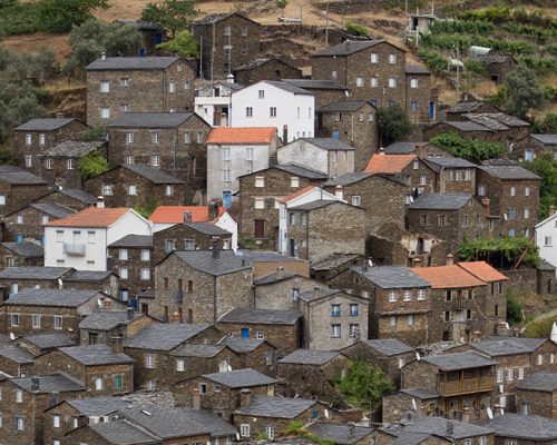
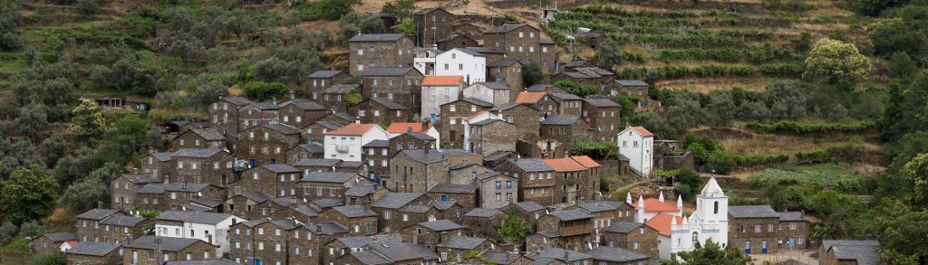
_PIÓDÃO_ On the south-facing slopes of the Serra do Açor we can find, at higher altitudes, strawberry trees and heather undergrowth. In the fall several interesting mushroom species appear, among which we highlight the Amanita muscaria. The Zêzere river dominates the landscape in this place and attracts the white wagtail and even the grey heron. Next to Piódão we are in the middle of Serra do Açor. Here the shrub formations dominate the landscape with some scattered clusters of chestnut trees appearing. We may find the fox or even the common genet. Closer to the villages we find crops, trees, and meadows on terraces. If we move to higher altitudes, with low undergrowth, we find ourselves in the favourite hunting ground of the common buzzard and the Montagu's harrier. _S. JORGE DA BEIRA_ The geographical barrier of the Açor and Cebola mountain ranges controls the humid winds from the west, leading to the local climate having continental and Mediterranean characteristics. Hot summers, cold and dry winters. The forest cover is predominately pine, nevertheless, the elements of the original flowers are still present. The evergreen oak and the cork oak form small clusters, along with an association of shrubs, with the strawberry tree (Arbutus unedo), the common hawthorn (Pterospartum tridentatum), and the heather (Erica spp.) standing out. Linked to the strawberry tree, one of the largest and most eye-catching butterflies of the Portuguese fauna can be seen here: the two-tailed pasha (Charaxes jasius). In this dense shrubbery, the Dartford warbler (Sylvia undata) hides, whereas the Algerian psammodromus (Psammodromos algirus) looks for a spot in the sun. _BOGAS DE CIMA_ The Bogas de Cima territory has a mountainous relief of schist soils, where maritime pine forests predominate. In the sunniest slopes, there are still some strawberry trees and evergreen oaks. In the valleys, the soil continues to be occupied by a subsistence agriculture, mainly of olive trees, arranged in terraces. The Bogas stream, a tributary of the Zêzere, is the main watercourse that passes by the village. In addition to its use for irrigation, it has also been used to operate the old olive oil press and the numerous water mills along its course. The natural gallery of alder trees and willows in the banks of the stream houses typical birds of this habitat, such as the Eurasian blackcap, the Cetti's warbler, and the grey wagtail, as well as the elusive otter. _PARTIDA_ It is in the valley of the Partida stream and other similar areas, in the immediate vicinity of the villages, that the humidity and soil fertility allow more demanding agricultural crops, such as olive groves, various fruit trees (orange trees), and vegetables. These spaces, which still harbour native riverside vegetation (alder trees and willows), are a stronghold of biodiversity and break the continuity of the forested areas on the adjacent slopes, mostly occupied by maritime pine and eucalypt. In the tree cover it is sometimes possible to find the cork oak, while the shrub cover presents strawberry trees, gum cistus, bell heathers, lentisks, and common hawthorns. The raven, the European green woodpecker, and the coal tit are part of the region’s avifauna. _CASTELO NOVO_ In the plain overlooking this village, near Atalaia do Campo, we find a mosaic of agricultural use dominated by olive groves, but with patches of rainfed crops and even oak. Next to the Alpreade stream, we can find the alder tree, the willow, and the narrow-leaved ash. Despite the strong human presence, birds such as the Eurasian tree sparrow, the corn bunting, or the stonechat can also be found. With the approach to the mountain range's “shell” where Castelo Novo is sheltered, we find a microclimate that enables fruit crops, particularly citrus. Next to the village we can see the black redstart or the blue rock thrush. This region is part of the Geopark Naturtejo, due to the interesting geological formations that exist here. It is also important to note the presence of Asphodelus bento-rainhae, a plant that is an exclusive endemism of the northern slope of Serra da Gardunha.
Difficulty level (scale from 1 to 5)