Piódão | Percurso Preto
![]() Piódão
Piódão
![]() 68.085 km
68.085 km
![]() Piódão
Piódão
![]() 6:00
6:00
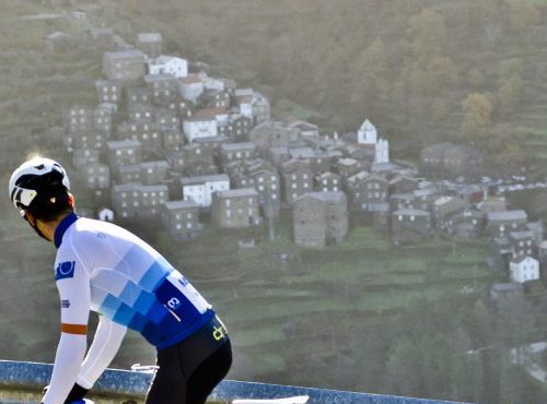
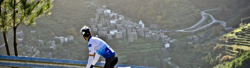
Places of passage: Vide, Foz D´Égua, Casas Figueiras, Abitureira, Rodeado, Parente, Alvôco das Várzeas, Rio de Mel, São Gião, Penalva do Alvo, Caldas de S. Paulo, Santo António do Alva, Aldeia das Dez, Goulinho, Vale de maceira, Gramaça, Vale do Torno, Soito da Ruiva,
This route leaves the main square of Piódão on the Vide road and runs downhill, steeply in some places. Some care is recommended on the way down, as there may be some traffic and the road is narrow and uneven, with steep slopes on the other side of the verge. The route is all downhill as far as Vide and the narrow road has a poor surface and no verges or protection. It passes through some hamlets lost in the mountains. Foz D'Égua, Casas Figueiras, Abitureira and Rodeado, among others. Before reaching Vide it takes a left turn onto the N230, next to the bridge over the river Alvôco. The route passes through Vide and follows the N230 for a few kilometres before turning right towards Rio de Mel. There is a somewhat steep climb after the turn and Rio de Mel is around 3 km away. The route continues for another 3 km after the village, but with friendlier gradients. After 20 km it starts the descent towards São Gião and the Alva River valley, a lesser known face of the Serra da Estrela Natural Park. After crossing the bridge over the Alva River, the route turns left and continues alongside the river, on the M514, as far as the Três Entradas Bridge, passing Penalva do Alva, Caldas de São Paulo and Santo António do Alva. At the Três Entradas Bridge it turns right and then left and starts to climb up to the Serra do Açor, with medium gradients of between 1 in 20 and 7 in 100, with more pronounced slopes in some places. The climb is about 12 km long and passes through some villages such as Aldeia das Dez, Goulinho and Vale de Maceira, with the mount of Senhora das Necessidades on the left and wonderful views of the Serra do Açor on the right, with its deep valleys and slopes dotted with small villages lost in time. Before reaching the top of the mountains the route turns right towards Gramaça and starts the descent, which becomes very steep between Gramaça and Vale do Torno, narrow and with a rough surface. At the bottom of the valley it turns left and starts the climb towards Soito da Ruiva, again dotted with areas with very steep slopes, requiring a bit of extra effort from the legs. This climb of over 600 m is around 7 km long to reach altitudes of close to 1000 m at the top. At the top there is a left turn and the route continues on a good surface and almost flat ground around the edge of the hills for 4 km before descending into Piódão on a road with a good surface for speed, and hairpin bends to warm up the brakes. The first glimpse of the Historical Village fills your soul with the image and the feeling that this is one of Portugal’s hidden treasures. It ends in the main square in Piódão.
Difficulty level (scale from 1 to 5)